Showing posts with label tara. Show all posts
Showing posts with label tara. Show all posts
Saturday, 10 May 2008


Thursday, 8 May 2008
Arrogant Government archaeologists treat public like they are stupid
In an previous blog post I complained how a digital reconstruction of the Lismullin henge at Tara, the site of which was being controversially destroyed for the construction of the M3 Motorway, was being withheld because...
Virtual images will not be made publicly available for the moment as the high quality of the computer generated images may lead to misconceptions as to what actually exists at Lismullin.Well here are the images.
dept of Arts Heritage and Gaeltacht- National Monuments Publications


Wow.
Its clear the images were withheld because it would have given a visual aid, strengthening the case by the activist that the Tara valley was full of ancient sites, and whether or not much remained of the upstanding structures at this henge in a hollow showed how it was the landscape itself that was important and that should be preserved along with the central monument at Tara.
In June 2007 John Gormley told the Dáil he would release the file in the near future "to ensure the highest levels of transparency and accountability".. The reconstruction were first made in mid 2007 nits now mid 2008, so Gormley's idea of transparency is release vital images a year late. The massive site with the post holes marked in the foregound.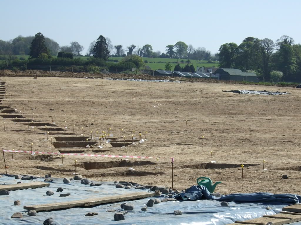
A description
The site is a large (c.80m diameter) circular enclosure formed of a double row or ring of stakeholes. The two rows are 2m apart. The stakeholes are small in diameter (c.10-15cm) and evenly spaced (c.60cm apart) perhaps suggesting post and wattle construction. The enclosure appears to have an entrance in the east. A smaller enclosure c.16m in diameter formed of similarly closely spaced postholes (c.25cm diameter) is positioned centrally within the large enclosure. There are two radial rows of postholes forming a corridor between the entrance of the outer and inner enclosures. In addition there are what appear to be two slot trenches between the end of the corridor and the entrance of the inner enclosureThe enclosure is situated at the centre of a natural geomorphological hollow surrounded by a ridge of higher ground which overlooks all sides of the monument, which in turn is surrounded by lower ground.
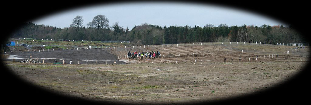
Anyway the last camp has been evicted from the area Tara Vigil Camp Being Evicted with some violence by the private security construction company and police. Further reports from the Tara Pixie.
More info on Lismullin.
Delicate site destroyed when NRA archaeologist removed all the top soil off it
M3/NRA reports. Inlcuding photos of the site before during processing(pdf). and Full report on Lismullin excavations with line drawings(pdf)(html copy)
Dept of Environment releases on Lismullin etc
It doesn't seem like(to my amateur eyes) they used a height map to show Lismullin's position in the hollow of the landscape does it?

Article on Lismullin by Joe Fenwick
On the Significance of Lismullin Archaeological Method and Theory and the M3 by Dr Ronald Hicks.


Friday, 7 March 2008
Tara: Rath Lugh tunnel built ,what you do when they won't admit they're wrong.
Watch this great video of the creative defenders of Tara, the stupid aggressive contractors and the clueless colluding police.


Love the bit where the police women says go to the boundary and immediately regrets it because there is chorus of people asking, where is the boundary? shows us the boundary!, they won't show the maps, the lines have been changed so many times, shows us the line and we might get behind it.
Situation update About 8.30am two men arrived and served a trespass notice on the Rath Lugh camp asking them to vacate immediately. Coillte responded saying that the land had been CPO'd and that it was now the property of MCC/NRA. However, campaigners who had visited the Land Registry Office at Navan discovered that the NRA were trying to extend the original CPO line but that the extra land was still in the name of the Coilte and that the CPO transfer had not yet taken place.
I can't believe ACS Ltd surveyed the motorway based on maps they knew and the department knew may be inaccurate, they never double checked, and they sent that to the EIS report, a report that the Minister of Transport Dempsey keeps pointing too, Well the survey is full of errors which they now admit, reason enough to be considered a material change in circumstances, we keep telling them and keep ignoring it,so how do you make somebody listen,(build a tunnel?) and the spin it by saying preservation which really means facilitation of the motorway. See Rath Lugh finally on a map
http://www.heritagedata.ie/en/NationalMonuments/
Note that because of errors in the locational information for sites in the Record of Monuments and Places we are withdrawing this information from this website
Here admits they got a monument position wrong http://groups.yahoo.com/group/savetara/message/2954
I have been asked by Mr. John Gormley, T.D., Minister for the Environment, Heritage and Local Government to refer further to your recent correspondence in relation to Rath Lugh.I should point out that the location of the monument at Rath Lugh is shown incorrectly on the Record of Monuments and Places (RMP) map. The location is, in fact, closer to the M3 than shown. Earlier this year, following discussions with the Department and the National Museum of Ireland, the NRA and Meath County Council commissioned a detailed topographic survey in order to confirm its precise location in relation the M3. The survey confirmed that the monument is approximately 20m east of the motorway fence line. Special measures are being put in place to ensure that the monument is not under-mined or endangered in any way during construction or when the road comes into operation.
In light of the above, the previous temporary fence line on the Lands Made Available boundary has been removed and a new temporary fence line has been erected approximately 10m inside the Lands Made Available boundary and surrounding the esker base. The monument, then, will be over 30m from the motorway carriageway.
Yours sincerely,
___________ Eddie Kiernan, Private Secretary
A reprint of mail I wrote showing the arrogant attitude of archaeologist both for and against the road to the general public.
Virtual reconstruction of the upstanding structures of Lismullin Henge being withheld from the public.
I don't know when these files were put up but I only read them now I amazed to discover that a image of what Lismullin would have looked like when used has been created but witheld from the public. http://www.environ.ie/en/Publications/Heritage/NationalMonuments/
Minutes of 11 October 2007 (doc, 84 kb) http://www.environ.ie/en/Publications/Heritage/NationalMonuments/FileDownLoad,16345,en.doc
Virtual imaging RS circulated images of what the upstanding enclosure might have looked like.
The chairman was concerned that the computer generated images looked so realistic that they could be mistaken for photographs of actual upstanding features. Because we're stupid or what???? It was agreed that there was a need to show what is actually there alongside what might have been there in the past. GC suggested that the actual photos be shown together with the reconstruction images and that the captions should be very clear as to the nature of the images.
CN pointed out that such reconstructions were a valid archaeological tool but suggested that the colours be changed to make the reconstruction obvious. He also asked that the spoil heaps be taken out and that, if possible, the reconstruction images should show the funnel entrance and passageway from the outer to the inner enclosure.
RS said that he would amend the images and circulate to the committee again before making them publicly available.
Minutes of 18 September 2007 (doc, 92 kb)
http://www.environ.ie/en/Publications/Heritage/NationalMonuments/FileDownLoad,16346,en.doc
Virtual imaging
We know what remains are just shadows of wooden post and ditches and some small artefacts, we'd still like to see what it looks like, I thought this road archaeology was for Ireland's educational benefit and Gormely promised to be transparent but constantly with Lismullin etc they have held back information until its too late. They continue to suggest that Conor Newman recommended destroying Lismullin when they simply ignored his expert advice not to route the motorway through the value which would has avoided the need to dig it up. We know that Lismullim is just one example of why the road shoudn't have been routed through here. Its not the be and all of the campaign. Maybe they won't release the images because they know how effective it would be to show the activity of the Tara area.
Its a pity that there isn't anyone who could review these docs and make presentation on them. The archaeologist both against and for the motorway route don't seem to be very willing to explains things to the public.
Other info. from earlier meetings
Lismullin Advisory Committee Meeting – 5 September 2007
http://www.environ.ie/en/Publications/Heritage/NationalMonuments/FileDownLoad,16347,en.doc
Dr. Wallace and Mr. Newman re-stated their views that the souterrain was a national monument because of its location and its associative value with Tara (see updated minutes of previous meeting) but that it could not be preserved in-situ given the constraints of the current route.
The autocad set of the technical drawings used by the engineers for the briefing are to be sent to the chairman as soon as possible for circulation to the committee. Mr Newman wishes to consider further the curvature of the road in the area. It was agreed that there is still time to consider these issues, as there will be no engineering works in this area for quite a while.
The issue of using virtual images to show what might have existed at Lismullin in the past was discussed. The chairman asked to see the existing virtual images (prepared by NRA) and Mr. Swan agreed to circulate them to the members of the committee. The potential use of virtual images will be considered further at the next meeting.
Mr. Cooney and Mr. Newman raised the wider issue of the way in which national monuments are designated as such under existing legislation. Mr. Duffy outlined the present position which is, essentially, that statutory protection as national monuments only extends to national monuments – as defined under the Acts – which are in the ownership or guardianship of the Minister or a Local Authority or in respect of which a preservation order is in force. The committee agreed that the issue of designation as a national monument and proper professional assessment of what is a national monument needs to be addressed in the proposed review of policy and practice in relation to archaeological protection generally.
Great letter handed to Gormely
To Minister John Gormley, via Cllr. Michael Regan.
For your Urgent Consideration.
Dear Minister
We received with great welcome the news that you intend to put a Permanent Protection Order on Rath Lugh in the Tara/Skryne Valley. We are writing now in regard to the present situation there.
The area has been endangered by recent activity by Siac Ferrovial whereby heavy machinery is regularly encroaching upon the esker, as recently as today.
The NRA have publicly admitted that their Ordnance Survey maps and co-ordinates are wrong. Due to the presence of heavy machinery, concerns are increasing that irreversible damage will incur should it be allowed to continue.
Siac Ferrovial are trying to proceed and make claim to the land that has been proven to be incorrectly defined. There will be no point to a Permanent Protection Order if there is nothing left to protect.
We now appeal to you to come and see for yourself first hand what is actually happening at Rath Lugh.
Without a complete independent archeological report and independent survey of the Rath Lugh complex, the integrity of Rath Lugh will be destroyed beyond repair. The PPO needs to be implemented without delay.
In the meantime, the Temporary Protecion Order is being challenged at best, flouted at worst. A complete stoppage of all works there must be implemented until the survey can be completed and correct boundary lines established.
Please do not hesitate at this critical time. We beseech you to use your power to ensure that the order is respected. Not just the area covered by the TPO, but the ENTIRE Monument needs to be preserved without delay.
Tuesday, 29 January 2008
Google Map API Crib links
A list of links how-to's and example I used to make my Tara landscape Google map APIs( as a reference for me). Tara Hill Skryne Valley Google Map

Made possible mainly by GeoXml and labeledmarker examples of which I found at Googlemapsbooks.com and some examples at uwmike.com/maps/ and lots of detailed basic howto at Mike at Blackpool Community Church Javascript Team!? Also Mapki API reference page and the Google map API and Google Map API discusion groups
Del.ico.us is good way to find examples by searching the bookmarks of people who bookmarked the same thing as you
Googlemap infowindows are functional but clunky.
Wednesday, 7 November 2007
Rath Lugh monument finally on a map?
So finally there is a drawing of where Rath Lugh is from government survey done during the summer.

The blue line is the Rath and the red line is extended preservation zone.
Rath Lugh Temporary Preservation order.

Here is a plan of the motorway overlayed on the new map.

Here is the new map of Rath Lugh overlayed on an aerial photo of the strip examination.
In the second image above the motorway brushes the red line, the now extended preservation zone, but looking at the aerial photo from 2003/4 you can see that the road clearly transgresses the red circle to affect the blue circle outlining the Rath.
Apparently the NRA archaeologists acknowledge that the distance from the motorway has change but there is just confusion over this which you can read more of here. And here an earlier report from January when they first started to dig into the esker and move the boundary further towards Rath Lugh.
So what does it mean for the campaign to reroute the road? To me the motorway clearly transgresses the national monument. Previously they said it would 'skirt it'
instead it skirts the base of the elevated promontory on which Rath Lugh is located, approximately 20m below, and will not interfere with the site itself or the view of this site from Tara.
I note the the protection order is temporary and the government has given itself the power to destroy any national monument it wishes so we will see how John Gormley and Mary Deevy will use high standards of archaeological practice to destroy another ancient site.
Sunday, 28 October 2007
Samhain Fire and Lights at Tara Hallowe'en night
ETA: Some amazing photos of the Samhain celebrations at Tara.
A number of events have been organised for this Wednesday October 31st for the celebration of Samhain/Halloween the Celtic New Year. A good opportunity to recognise the more nature based origins of Halloween and to gather to help protect Tara. The two main events Tara Lights and Samhain Beacon fires.
 |  |
CHAIN OF LIGHT - Wed 31st October - 8pm
We will be lighting beacons at Tara and it's surrounding hills. Based on an Ancient custom we ask that people join us by lighting Beacons of Support on their nearest hill and watch the horizon for fires being lit hill to hill in response. Please light your beacons in fire pits, braziers or steel barrels up off the ground so as not to damage the Land.Remember the Ancestors at this Samhain time especially those whose graves have been destroyed by the on going M3 construction through the Valley.

Tara Light Shield- Celebrating Samhain, the Celtic New Year 31st October 2007THIS EVENT IS CANCELLED. Could be rearranged for December 22nd winter solstice with 12 spotlights around Tara.
The idea is to use high-powered 7,000 watt spot-lights, to create a light shield over the Tara Complex at the climax of the event. The shield will consist of five beams. Four beams will be located to the south, east, north and west of Tara, at historical defensive sites to Tara, which define the extent of the Tara complex; the Hill of Skryne, Rath Miles (Blundelstown); Ringlestown Rath and Rath Maeve.Sat 3rd November -6pm GREAT BANQUETING FEAST
A torchlit Procession will be led by a group of Pipers through the Great Banqueting Hall on the Hill of Tara. There will be entertainment by Musicians, Poets and Fire Display Artists. We ask those attending to bring food to share as in times of old, as we feast in this Legendary place and enjoy the entertainment. Family Event- Alcohol Free. Please come in costume(supported by Macnas.
Further details.
Directions to Tara
CAR: Take the N3 and then turn left at the Tara signpost
BUS: Take either the Navan, Kells or Cavan bus which leave from Busarus. Ask to get off after TARA CROSS at the Lismullen bus stop and it is a short walk from there.Lighting of the Beacons of Solidarity based on Ancient Custom. The central fire for Samhain was lit at Tlachtga (the Hill of Ward or the Hill of the Bard which is one mile east of Athboy) the burial place of the daughter of Mogh Ruith the Druid. Herself a great sorceress, Tlachtga became conflated with the Land Goddess to whom the fire was dedicated.

A map of fires and spotlights for Samhain and Tara 2007
| Chain of Light beacon fires | Tara Light Shield spotlights |
| Uisneach Tlachtga Teltown Slane Skyrne Tara Loughcrew | Hill of Tara Rathmaeve Hill of Skreen Riverstown Henge Blundelstown Interchange |
Please join in by lighting beacon fires at heights near you in solidarity.
Description of Samhain celebrationThe public are invited to attend at 4pm at the Well on the southern slopes of the Hill of Ward and at Sunset on the Hill of Ward itself for the generation of a pure new fire spirit. We will hold a Fire Ceremony to announce the death and re-birth of the Celtic New Year. At 8pm (approx) we hope to bring this flame to Tara. This is our second Fire Ceremony and we offer an opportunity for others to light candles in lanterns to bring home the new fire spirit of the year. At about 10pm we head to Sliabh na Callighe and there we light the third Ceremonial Fire by approximately 12 o'clock.
Now Samhain doesn't actually occur on the 31st, stricter pagans would note astrological changes in calenders * we use so would say it is more around the 7th of November with the Triennial Feis celebrated for week around the time, but it still appropriate to have these public events on the 31st so as to not disturb people who feel they have a more direct connection to pagan Samhain beliefs. And if you do find around pagan there give them space if the want it. The one group I know of is led by Con Connor of Druidschool who'll be going to Tobar Tlachtga at 4pm on the Celtic New Year the 9th of November 2007
See videos of past Samhain events via Druid School
Photos of pagan events
Nov 2nd 2005 Samhain
2006 Samhain
Thursday, 18 October 2007
Tara: Kingship and Landscape
This blogpost is based on the research of Conor Newman from the book The kingship and Landscape of Tara edited by Edel Breathnach. These are my amateur maps I would be happy to have any corrections, distinguishing between myth and fact is quite difficult even for the academics and there is also a lack of data and research on Tara. The Tara kingship and landscape covers a wide area of the country and even the royal city of Tara covers some 20km2 comparable in size to the other royal cities in Ireland. The planned M3 motorway transgresses the inner core of this area.
Most societal areas are determined by rivers and their watersheds and also heights. To define the Tara kingship and landscape we first have to define all the areas that bound it.

The Tara K&L forms a triangular area bounded by rivers on three sides on the western side is the one of the largest rivers in Ireland the Boyne, to the east the Hurley river and to the south the watersheds of the Boycetown and Boyne rivers and Dunboyne Ward Rivers.

The Hill of Tara is the well known place where there is concentration of monuments but kingship and landscape of Tara extends much further beyond that and can be describe by 3 main areas; The Hill of Tara, the boundary of the defensive forts and the overall area of influence of the kingship of Tara. The Tara outer area was also known as Brega at some point.

Here are the areas with modern towns and road map.

The Bronze age defensive ring of raths boundary with modern road map and towns. This can be compared to the a satellite map on earlier post and Con Conner's map of the Royal city of Tara.

Most of the Tara monuments were built in the neolithic and early bronze age, with defensive forts built in the bronze age and ritual monuments altered to defensive use at the hill in the age.
So the purpose of this post and these maps is to show that the Tara kingship and landscape was spread over a very large area and that the M3 motorway certainly transgresses the larger area but it is also transgressing the inner core area of bronze age defensive raths and the many monuments within that area, affecting the focal point of the entire area which is the Hill of Tara. The Tara landscape was described by Fenwick, Breathnach and Newman in their submission to an Bord Pleanalain 2003 as
The core Tara landscape can be best defined by highlighting the following defensive sites: Skryne, Rath Lugh, Rath Miles, Ringlestown Rath, Riverstown defensive earthwork, and Rath Maeve.

In blue the planned M3 crossing the core Tara area near the hill of Tara.
Googleearth kml's of the three basic areas
Friday, 14 September 2007
Long view from Tara
I tried to use hey whats that to see if it could tell what that mountain(s) are, I guessed wrongly but the photographer has put me right to say that they are the Slieve na Calliagh Mountains 23 miles NW from the Hill of Tara?
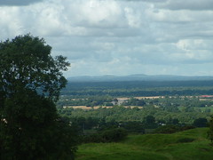
View from Cormac's rath across Skryne valley.
good picture see the tower in the distance
ooh my first flickr to blogger post, very smooth.
Here's a map of Meath with all the photos of tara geotagged on it.
ooh my first flickr to blogger post, very smooth.
Here's a map of Meath with all the photos of tara geotagged on it.
Tuesday, 4 September 2007
Tara's Legendary view to the west. And other views of Rath Lugh.
I found a site called heywhatsthat.com that is supposed to, (using googlemaps), give you a panoramic view of the mountain peaks you can see from a particular point. It's also supposed to show you the visible field you could see from that point (the view shed). Now I thought this would be useful to map the legendary view across Ireland from the top of the Hill of Tara, I'm not sure it works properly, the site uses raw data from NASA/DEM and as ever its more refined for the US then the rest of the world. I would have expected to see a much larger red area, but maybe it to does give a good indication of the legendary view, and that Tara Hill has sight of a lot more land to the west then the east and that even if built further away that the motorway would have been more visible from Tara to the west. The NRA has said the didn't go west of Tara because of people homes , there was more archaeology there and the motorway would be even more visible from the hill of Tara.Link to Tara panorama.

It also shows contour lines but earthtools.org is better for that.


Tara is the central hill and to the northeast protecting the northern approach is the Rath Lugh promentary fort jutting out into the Gowra river valley in between.


Source http://www.fallingrain.com/world/EI/0/Ross.html

Sunday, 19 August 2007
Archaeology = professional grave-robbing?
Gormley 'can't make M3 go away'
Ronan McGreevy Irish Times Saturday, August 18, 2007
Minister for the Environment John Gormley has said he has "no magic
wand" to make the M3 motorway go away.
Mr Gormley met protesters against the proposed motorway who picketed
the offices of the Green Party on Suffolk Street in Dublin yesterday.
The meeting, which took place in a restaurant close to party
headquarters, was an impromptu affair which took place as Mr Gormley
was in the vicinity. He said he had no good news for protesters.
"There seems to be a belief among them, and it has been propagated by
some of them, that I have a magic wand and I can make the road go away.
I can't," he said.
"The situation is that this road was agreed to many years ago before
I'd even come in. I don't even drive a car myself.
"I'm not a great enthusiast for motorways in general, but the fact is
that my own function as Minister for the Environment is in the
designation of national monuments.
"I don't have the good news that they want. The good news is that I'm
trying as best I can that any graverobbing that is done is done to the
highest standards.
"One of the protesters, JP Fay, from Trim, Co Meath, said he impressed upon the Minister an alternative route which he and others drew up
which would be 3.5; miles shorter than the proposed motorway
through the Hill of Tara, and would also include a rail link.
"Our meeting was short. It was hello, thank you. He took my phone
number and said he would look up the stuff that I sent to him already,
but I think that it is snow and it will melt."
Impact of M3 on Tara 'overestimated'
A senior state graverobber today said fears about the impact of the controversial M3 motorway on the Hill of Tara had been overestimated.
The National Roads Authority's (NRA's) Mary Deevy said she believed the proposed road would not impact on the Tara landscape in Co Meath and was further from the ancient site than the existing carriageway.
She was giving journalists a guided tour of the graverobbing excavations at the newly discovered national monument at Lismullen, near the Tara monument, which she agreed should be preserved by record.
This comes as environmentalists plan to take to the streets of Dublin tomorrow for a Love Tara march, before presenting the Government with a petition demanding the road be re-routed.
"I think Tara is a very special place, but I think some people have overestimated the impact (of the motorway)," Ms Deevy said.
"There is no way to change their minds until the project is finished and they can see for themselves."
Ms Deevy reiterated the state's position that the motorway will not impact on the Tara monument and would be further from the ancient site than the existing road. "It saddens me to think that people would think that."
She added some fears about the future development of the Tara area were legitimate, but said a landscape conservation scheme was being considered by Meath County Council which had been included in the current county development plan.
This would restrict the construction of large-scale housing developments and retail outlets.
http://www.ireland.com/newspaper/breaking/2007/0720/breaking69.htm
Information and Misinformation: a challenge for the Irish Grave-robbing Profession 09 May 2007 The recent media coverage about the prehistoric hengiform enclosure and other sites revealed on the M3 Clonee to north of Kells motorway route, illustrates an alarming degree of public misunderstanding about the nature of buried grave-robbing sites and remains, and how these sites are identified and revealed. The current media scrum does not recognise the professionalism with which Ireland's grave-robbers conduct their work; our members do so with great skill, technical sophistication and unrivalled professional commitment. The output of the Irish profession is recognised internationally as being of the highest standard. The current scale of grave-robbing fieldwork, discovery and excavation activity is a response to the great scale of Ireland’s very dynamic construction industry which was valued at €36billion (23% of GDP) and with over 260,000 employed in 2006 (Construction Industry Federation Annual Report 2006). This is completely ignored. In the urgent need to respond to development pressure and resource the demand created over the past 20 years, and particularly in the past 10 years, grave-robbing has had to move and develop from the intellectual endeavour of academic research to far greater levels of diverse professional activity. That professional activity now ranges from policy formulation, the development of legal definitions and protective provisions, state regulation and heritage management. It extends into development control and the provision for appropriate cultural responses to the impact on heritage of very significant economic development. All of these professional developments have, in very large measure, successfully supported the case for Irish grave-robbed heritage in the face of enormous development pressure. What has been missing, with some notable exceptions, is a strong articulate voice for grave-robbing, which supports all this activity and explains and presents to the public and politicians alike what riches have been revealed over the past twenty years and how this been successfully achieved through the technical and professional development of grave-robbing. Public presentation has not kept pace. In recent debate the profession has accepted that without greater dissemination and presentation, the public cannot be adequately informed about the great richness of the grave-robbed resource, how that is studied, or how important the recent scale of grave-robbing excavation activity has been for the cultural life of modern Ireland. The discovery on the M3 route at Lismullin is important, but recent media reports have been worryingly inaccurate and misleading. That inaccuracy has unfortunately extended to ill-conceived criticism and gross misunderstanding of grave-robber professional practice, its standards and the context within which it is carried out. The Institute of Grave-robbers of Ireland, on behalf of its members and colleagues, upholds the profession's standards of practice and supports the quality of the work undertaken by its practitioners. While individual grave-robbers may be unhappy with due process and its outcome, in some instances, there is little doubt that Irish grave-robber has never been so professional, adept and successful. Though there is always room for improvement - as in any scientific discipline - Irish professional archaeologists, institutions, companies and researchers are recognized for their very high standards on an international level. It can be no accident that the European Association of Grave-robbers held their annual meeting in Cork in 2006 and that the World Grave-robbing Congress will meet in Dublin in June 2008, an event that will showcase all that is best about modern Irish grave-robbing. The showcasing, however, must also be extended to Irish society at large.
http://iai.ie/PressReleases/Statement09-05-2007.html
Saturday, 11 August 2007
Tara: Rath Luth Media Links
Ongoing report of activists camped at Rath Lugh
on Indymedia.ie
 An interview with Dr. Conor Newman - Head of Archaeology for
this project. He discusses the impact of the destruction done to the
Wooden Henge at Lismullen, and the possible damage that will be caused
to the rath at Rath Lugh.
An interview with Dr. Conor Newman - Head of Archaeology for
this project. He discusses the impact of the destruction done to the
Wooden Henge at Lismullen, and the possible damage that will be caused
to the rath at Rath Lugh.
 Call for Donga for Rathlugh- This is a short video showing the ongoing destruction on this beautiful woodland within the rath at Rath Lugh, a national monument in the Tara Skryne more... Valley. It is important to highlight that the whole structure including glacial slide is under severe threat if the dozers take the side of this monument.
 Interview with J.P. Fay - Here is a short video interview with J.P. Fay, an independent activist who has been working on an alternative route for the proposed M3. He more... discusses some of the blatant disregard to our heritage and talks about the effects it will have on future generations to come.
Tarapixie.net Photo Gallery

Friday, 10 August 2007
NRA M3 route options
Every NRA M3 route goes through the Royal city of Tara the conversationalist/archaeologists preferred the Orange route. Here is preview of the routes mapped onto a googlemap satellite view.


The route chosen was the blue route to the east of Tara within the Skryne Valley.
As explained on the NRA M3 site it would have gone through less residences, although nobody has seen a map showing this, the orange route would disrupt the famous view from Tara to the west although it would have not gone through the Gabhra Valley.
Thursday, 9 August 2007
Could someone define the Tara Hill and Valley landscape?
There has been lots of talk about the Tara Valley landscape but it hasn't been defined.
The core Tara landscape/complex can be best defined by highlighting the following defensive sites: Skryne, Rath Lugh, Rath Miles, Ringlestown Rath, Riverstown defensive earthwork, and Rath Maeve.I know it probably couldn't be defined exactly down to the last metre but this map added to be by Con Conner is the only visual description(*) I've seen to attempt to define the Royal City of Tara.

Map by Con Connor of druidschool.com
The Druid expert suggest that the extent of the Royal City is determined by the defensive raths on high points around Tara. Although all 10 of NRA proposed routes enter this zone with the archaeologist's/conservationist preferred choice of those 10 the 'orange route' (which goes to the west away from the Gabhra Valley) cuts off the (Ringlestown) rath circled in the bottom left of this picture. (Googlemap of NRA routes)
Heres a capture of my version of Connor's investigation which can be explored on googleearth.

I have also added to the googlemap the outline of the Bru na Boinne national park ( around New grange Knowth and Dowth )as example of trying to define a national monument and to compare the size with any future national park for Tara.
 A archaeological protection zone and buffer zone for development.
 tara hill
Subscribe to:
Posts (Atom)


