Showing posts with label rath lugh. Show all posts
Showing posts with label rath lugh. Show all posts
Saturday, 10 May 2008


Thursday, 31 January 2008
Save Tara vs M3 protest update
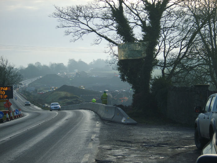 The scene of ???struction at Soldiers Hill Meath.
I haven't been following the issue at Tara/M3 very much lately it just seems doomed (M3 route likely to open ahead of 2010 deadline), although when people reference the nature reserve in California that had roads and lamp posts installed yet was saved from development it does hearten me, as does the video of people still disrupting the work of the construction sites.
See in this video how to handle constructions workers who misdirect their aggression.(Skip to 13 mins).
You get paid either way so why are you trying to run me down, huh?
The protest haven't been getting very much coverage even by the tabloids in alarmist way. You wouldn't know it but they have been people standing in front of bulldozer every other day for weeks, disrupting work for hours until the police come take their names and they leave voluntarily, today people locked on to a bulldozer and had to be cut out they were arrested. You can follow updates from the direct actioners and campers at their blog at http://www.tarapixie.net
What was left of the Lismullin Henge has been destroyed and covered over.
Here's more photos of Tara/M3 sites on 27th to January 08 and 28th jan via MNiB
There seems to be some people and environemtal NGO groups lobbying to get UNESCO conservation for Tara but it just doesn't suit the government to submit it, they are the only body that can. (Irish Times: State fails to use heritage site register). Email them.
Excellent letter to the Indo debunking the myths about "best archaeological practice".
Debunking Tara debate myths
Wednesday January 23 2008
It seems times haven't changed since former minister Michael Smith bravely faced, with "no practical evidence", a decision to act on allegations of planning corruption and untoward pressure being put on councillors on re-zoning.
All communication with the government on the M3 planning tribunal explaining the errors made during the process has also been met with anger and denials based on the following incorrect facts.
1. The decision was made with the best archaeological advice -- incorrect. both the Discovery Project and Conor Newman objected at the tribunal
2. It is further from Tara than the old N3 and therefore better-- incorrect. The intrusive 52-acre Blundelstown Interchange is the same distance from Tara. The Lismullen monument is just over a mile from the Hill. The motorway is a mere 20 metres from Rath Lugh. Does this sound better?
3. It is good to excavate. Let me quote from the Time Team in 2003 when they revisited Athelney, in Somerset, after 10 years. Looking at the new geophysical survey, they extolled the advances in the technology since their first visit in 1993. They remarked: "In a few years we won't need to dig".
Sadly this is now looking too late for Tara. There is still time for our politicians to take a stand, based on their own personal consciences, and bestow the greatest gift they can to their grandchildren, a remodelled Lismullen national monument interpretive site and an pristine, intact valley.
PAULINE BLEACH
SALTHILL, CO GALWAY
Saturday, 26 January 2008
Dublin Electoral Constituency Google map
Anyone coming to my blog looking for Dail constituencies, I don't have em.
The official Constituency Commission has images and detailed reports on the boundaries and changes.
Go here for the 2012 boundaries in google-kml http://www.tallyroom.com.au/maps (freeif credited to Ben Raue ) or here for more detailed ones with Electoral (sub) Divisions http://icampaigned.com/blog/dail-constituency-maps/ (not free) or go Ordnance Survey Ireland for commercial use files.
Of course I think digital boundaries files of useful detail should be information should be free for non-commercial reuse.
I had traced on the Dublin city and County Electoral commission for 2004 and made it available on bbs.keyhole.com but the Electoral Commission put out a report and new maps for 2012.

Dublin County Constituency (draft v2.0) and for Google Earth program and for Googlemaps to view in your browser

A lot of outer Dublin wasn't very clear in GE but they updated some areas like the Dublin mountains so I can trace the border more accurately, but not the very northwest of county Dublin.
Just the Dublin City Electoral Constituency (draft v2.0) for Google Earth program and for Googlemap to view in your browser.
So I've updated them here I consider it still a draft until more eyes have been on it to spot any mistakes I may have made. I had hesitated on publicising them more because I thought maybe bad maps are worse then no maps. But along as have caveats about their accuracy people may still find them useful. At some point I saved an old map over a newer ones I had double checked which so I wasn't sure which I had double checked which browned me off on the whole thing. As new higher resolution photos of Dublin appear the lines no longer match exactly...:/ And the commission maps doesn't stretch and match over the GE satellite image either. I don't think they'll ever be perfect.
I'll add links descriptions, TD's, election result and other constituency stats.
2004 Dublin City and County Constituency Commission polygons and map overlay draft 2004
The Index of streets of the electoral register for Dublin City might be helpful to you, via Vocal Voter.
Dail at wikipedia Politics.ie Dail wiki Boundaries at electionsireland.org South Dublin
PS. The creator of itison.tv has pointed there the OSI have new web service called Smartmaps He shows us some different views of Tara, Rath Lugh and Lismullin. There have couple of different types of maps you can buy but you can't seem to preview them. Also strangely there are earlier maps then the ones at the NPWS with maps from ~2003 that shows the scar of the M3 going through Tara, these aerial photos are very different a step clearer and brighter feel 70's.
PPS. Eirepreneur continues to jump start Irish uses of new mapping apps by giving an example of a collaborate google mymap, he has started one on wifi hotspots. I hope to find a project to create my own and get people involved. I was wondering would it be efficient to use this collaborative method to create maps for the constituencies for the rest of Ireland and the European and local elections, but I don't know whether hand traced maps data would eventually be useful for anybody to use and mash up to display other information. Any other ideas for useful Irish collaborative maps?
Wednesday, 7 November 2007
Rath Lugh monument finally on a map?
So finally there is a drawing of where Rath Lugh is from government survey done during the summer.

The blue line is the Rath and the red line is extended preservation zone.
Rath Lugh Temporary Preservation order.

Here is a plan of the motorway overlayed on the new map.

Here is the new map of Rath Lugh overlayed on an aerial photo of the strip examination.
In the second image above the motorway brushes the red line, the now extended preservation zone, but looking at the aerial photo from 2003/4 you can see that the road clearly transgresses the red circle to affect the blue circle outlining the Rath.
Apparently the NRA archaeologists acknowledge that the distance from the motorway has change but there is just confusion over this which you can read more of here. And here an earlier report from January when they first started to dig into the esker and move the boundary further towards Rath Lugh.
So what does it mean for the campaign to reroute the road? To me the motorway clearly transgresses the national monument. Previously they said it would 'skirt it'
instead it skirts the base of the elevated promontory on which Rath Lugh is located, approximately 20m below, and will not interfere with the site itself or the view of this site from Tara.
I note the the protection order is temporary and the government has given itself the power to destroy any national monument it wishes so we will see how John Gormley and Mary Deevy will use high standards of archaeological practice to destroy another ancient site.
Friday, 10 August 2007
Rath Lugh directly affected by M3 motorway in Tara Valley

Oct 2007: here some detailed researched on the confusion over Rath Lugh by John Farrelly Posted here
Rath Lugh is a promontory fort over looking the Gabhra Valley, a man made addition to an esker of earth and gravel now covered in trees, a part of defensive zone around Tara. The land originally belond to coillte (the Irish state forestry company) and was given to the NRA who began clearing the trees and digging into the mound in February 2007. In August while focus in the media was on Lismullin workers excavated further into the corpse on Rath Lugh.
As far as I know no (new) archaelogical survey has been carried out on Rath Lugh as the fort itself is not inside the road take. The above aerial photos(*) shows the rath marked in the trees but I have not seen a precise position of the rath but NRA said it wouldn't be affected.. here
Rath Lugh is today separated from Tara by the existing N3 and lies under dense vegetation and tree cover. It was not possible to route the M3 to the east of the site, instead it skirts the base of the elevated promontory on which Rath Lugh is located, approximately 20m below, and will not interfere with the site itself or the view of this site from Tara.Then the NRA said that the line of the fence (photo) was as far as the work would go. And the chief archeaologist Mary Deevy said that excavations were at a part of an esker ridge - two fields away from Rath Lugh". A campaigner Terry tried to drag information out of the NRA who said a retaining wall would be built to prevent further damage of the esker, now maybe the rath itself is not directly affected but the rath's purpose was it's setting which now has been damaged. as DR Conor Newman consultant archaeologist explains.


A series of photos taken in January
 Series of photos from April.
 Series of photos from August.

A report of a visit to Rath Lugh via Mythical Ireland

A series of photos from mid August.

Photos taken by Dr. Muireann Ni Bhrolchain a Celtic studies professor very active in trying to conserve Tara. Albums of photos of Temair
Rath Lugh circled in fig 3 of this pdf By my eye its 75metres away from the road on that map, and the M3 is describe by the NRA as 20 metres below the fort.
Subscribe to:
Posts (Atom)


